Fatherland II & Joint CW Tech-Tre

Would you like to react to this message? Create an account in a few clicks or log in to continue.
Fatherland II & Joint CW Tech-Tre

This form is intended to be a platform for the developers of Fatherland II, a modification for Hearts of Iron 3, and those who are interested in contributing with ideas.


4 posters

    Borders in Europe

    Karelian
    Karelian


    Posts : 230
    Join date : 2009-08-11

    Borders in Europe Empty Borders in Europe

    Post  Karelian Tue Feb 23, 2010 3:31 pm

    This is the part of the world where most of the changes are going to take place. Even though Rawrawrbangbang has seemingly faded away from the forum, I´d still prefer to use his country tag system and the maps of New Europe as basis:

    Code:

    # Special countries
    REB = "countries/Rebels.txt"

    # Northern Europe
    DEN = "countries/Denmark.txt"
    EST = "countries/Estonia.txt"
    GES = "countries/Generalbezirk Estland.txt"
    GLE = "countries/Generalbezirk Lettland.txt"
    GLI = "countries/Generalbezirk Litauen.txt"
    FIN = "countries/Finland.txt"
    FOI = "countries/Faroe Islands.txt"
    ICE = "countries/Iceland.txt"
    LAT = "countries/Latvia.txt"
    LIT = "countries/Lithuania.txt"
    NOR = "countries/Norway.txt"
    SWE = "countries/Sweden.txt"

    # Western Europe
    BEL = "countries/Belgium.txt"
    ENG = "countries/Great Britain.txt"
    FRA = "countries/French State.txt"
    HOL = "countries/Netherlands.txt"
    IRE = "countries/Ireland.txt"
    REF = "countries/Reichsgau Flanders.txt"
    REN = "countries/Reichsgau Nederland.txt"
    REW = "countries/Reichsgau Wallonia.txt"
    SCH = "countries/Switzerland.txt"

    # Southern Europe
    ITA = "countries/Republic of Italy.txt"
    POR = "countries/Portugal.txt"
    RSI = "countries/Italian Social Republic.txt"
    SPA = "countries/Spain.txt"

    # Central and Eastern Europe
    AUS = "countries/Austria.txt"
    CZE = "countries/Czechoslovakia.txt"
    GER = "countries/Germany.txt
    GGR = "countries/Greater German Reich.txt"
    HUN = "countries/Hungary.txt"
    MOS = "countries/Moscow Federation.txt"
    ROM = "countries/Romania.txt"
    SLO = "countries/Slovakia.txt"
    UKR = "countries/Ukraine.txt"
    VOL = "countries/Volga-Tataria.txt"
    UDM = "countries/Udmurtia.txt"
    WRU = "countries/White Rutenia.txt"

    # Southeast Europe
    ALB = "countries/Albania.txt"
    BUL = "countries/Bulgaria.txt"
    CRO = "countries/Croatia.txt"
    GRE = "countries/Greece.txt"
    HUN = "countries/Hungary.txt"
    KOG = "countries/Kingdom of Greece.txt"
    MON = "countries/Montenegro.txt"
    ROM = "countries/Romania.txt"
    SER = "countries/Serbia.txt"
    YUG = "countries/Yugoslavia.txt"

    # Asia Minor and Caucasus
    ARM = "countries/Armenia.txt"
    AZE = "countries/Azerbaijan.txt"
    DAG = "countries/Dagestan.txt"
    GEO = "countries/Georgia.txt"
    KAL = "countries/Kalmykia.txt"
    KUB = "countries/Kuban.txt"
    TUR = "countries/Turkey.txt"

    IMO the starting borders should be based on the situation of world on 22nd of April 1946, the day WWII finally ends. Once I get the map I´ll post further info about the way I plan to divide the task of modding the borders.

    Edit: The best way to deal would be to divide the map into geographical regions that could then be modded by different persons - while the whole project is obviously immense, dividing it up between several individuals will hopefully ease things out and allow more people to participate.
    Black Guardian
    Black Guardian
    Admin


    Posts : 192
    Join date : 2009-06-13
    Location : Saxony

    Borders in Europe Empty Re: Borders in Europe

    Post  Black Guardian Tue Feb 23, 2010 4:37 pm

    Karelian wrote:
    Edit: The best way to deal would be to divide the map into geographical regions that could then be modded by different persons - while the whole project is obviously immense, dividing it up between several individuals will hopefully ease things out and allow more people to participate.

    Of course this is the only way to approach such a task. There is a proverb: "How do you eat an elephant?" - "Bit by bit"

    Let´s do this step by step - maybe we can already start with preparation for our work, considering the fact that the map-mod does not change the provinces in most parts of Europe (except eastern europe, where unfortunately most of our changes will happen) but only redraw the rivers, we can already start looking which provinces to assign to which country in Southern Europe (Italy & Balkan), maybe with a nice picture-map featuring HoI3-Provinces (if something like this does exist?) where we can color the zones and assign province numbers to have a better visualization when addings things later, when the newest version of the map-mod is out?
    Furthermore, this would finally give the impression of progress for the guys watching our development, and pose a good guideline for volunteers willing to do a bit of the work with clear instructions ("Here is a map of how it is supposed to look like in the end, now proceed!").
    Karelian
    Karelian


    Posts : 230
    Join date : 2009-08-11

    Borders in Europe Empty Re: Borders in Europe

    Post  Karelian Wed Feb 24, 2010 1:57 am

    Black Guardian wrote:
    Karelian wrote:
    Edit: The best way to deal would be to divide the map into geographical regions that could then be modded by different persons - while the whole project is obviously immense, dividing it up between several individuals will hopefully ease things out and allow more people to participate.

    Of course this is the only way to approach such a task. There is a proverb: "How do you eat an elephant?" - "Bit by bit"

    Let´s do this step by step - maybe we can already start with preparation for our work, considering the fact that the map-mod does not change the provinces in most parts of Europe (except eastern europe, where unfortunately most of our changes will happen) but only redraw the rivers, we can already start looking which provinces to assign to which country in Southern Europe (Italy & Balkan), maybe with a nice picture-map featuring HoI3-Provinces (if something like this does exist?) where we can color the zones and assign province numbers to have a better visualization when addings things later, when the newest version of the map-mod is out?
    Furthermore, this would finally give the impression of progress for the guys watching our development, and pose a good guideline for volunteers willing to do a bit of the work with clear instructions ("Here is a map of how it is supposed to look like in the end, now proceed!").

    I do have the province map of HoI3 and an early version of such a map already exists:
    Borders in Europe Riviiva
    Obviously this one contains clear geographical errors from my part (getting the borders 100% right by using a non-HoI map as a reference was harder than one would think) and I´ll supplement it by taking screenshots from province layout and then editing these in-game images by making the intented borders visible there.


    Here´s latest news regarding the status of Magrathea:
    I just thought I'd give you an update on Magrathea. I'm basically done with Europe now. Ukraine, Belarus, Moldova, Kazakhstan, and the German states have been added. It just now occurs to me that I'll need to add Russia/Siberia, but those should be much easier and quicker. Besides adding those two nations, I'd also like to rename some cities in Russia (along the Kazakh border and along the Ukrainian border) and within Germany. I think that would be the best time to send the files your way.

    Right now I'm experimenting with adding urban terrain (I only just got photoshop, needed for editing the terrain map). If it works, I'll move incorrectly placed urban terrain (NYC, Berlin, SanFran) and add a couple ones as well. This would also be updated by the time you get the files. But if I need more time in getting it to work, you should go by the city names provided.

    Karl

    And here are some screenshots:
    http://www.europa-universalis.com/forum/showpost.php?p=10817282&postcount=78
    Black Guardian
    Black Guardian
    Admin


    Posts : 192
    Join date : 2009-06-13
    Location : Saxony

    Borders in Europe Empty Re: Borders in Europe

    Post  Black Guardian Thu Feb 25, 2010 12:05 am

    Well, while a nice transfer of the Map of New Europe, I think it does not represent the actual political boundaries of the time, at least it is not clearly distincted.

    For example, is Flanders/Wallonia/Netherlands now one country or three?
    Same question for the Protectorate Bohemia-Moravia and General Gouvernment of Poland - German puppets or German (non-core) territory?

    Those are the question that remain oblivious to me - How will they be represented in the game?
    And how will the Free city of Rome be represented? Own country? Western (US) control?

    Maybe we can shape a nice depiction of how things are going to finally look ingame (with different colors for different countries) to suggest people we are doing something serious here with some good plans and progress Wink
    Karelian
    Karelian


    Posts : 230
    Join date : 2009-08-11

    Borders in Europe Empty Re: Borders in Europe

    Post  Karelian Thu Feb 25, 2010 1:19 am

    Black Guardian wrote:Maybe we can shape a nice depiction of how things are going to finally look ingame (with different colors for different countries) to suggest people we are doing something serious here with some good plans and progress Wink

    That may indeed be the case Wink
    I´ll see to it during this week.
    Black Guardian
    Black Guardian
    Admin


    Posts : 192
    Join date : 2009-06-13
    Location : Saxony

    Borders in Europe Empty Re: Borders in Europe

    Post  Black Guardian Sun Feb 28, 2010 10:31 pm

    A small graphic workout of how Italy will look like in-game...

    Borders in Europe Italia10
    Karelian
    Karelian


    Posts : 230
    Join date : 2009-08-11

    Borders in Europe Empty Re: Borders in Europe

    Post  Karelian Mon Mar 08, 2010 10:46 pm

    We´re getting closer, if this timetable holds we can finally start the scenario editing during this weekend. Delays are always possible but great news nevertheless.


    08-03-2010, 03:52
    Re: What´s new since last time?
    What I have left to do:

    Add Russia/Siberia as nations (since this is automated, it shouldn't take too long...I just hope the natural break between the Siberia and Soviet Union province folders is good enough so I don't have to do any manual edits.

    Move industry in certain Russian cities. When I moved cities to conform to the Ukrainian/Kazakh/Belarusian boundaries, major cities shifted. I have these cities circled, and it shouldn't take too long.

    Relocate the trans-Siberian RR infrastructure line to coincide with major cities that I shifted.

    Very minor touch:

    eliminated boundary between Germany and Latvia

    I'll be somewhat busy until Tuesday. On Wed/Thursday I should have enough time to hammer out whatever I have left. I should have this ready for you Thursday night (Friday morning to you).

    Krazy19Karl


    EDIT BG: moved from the Organisation of Work-Thread - Italian Borders

    Since you are making the Italian borders:

    Borders in Europe Italiavk0

    Borders in Europe Rsiwest
    (It would be better if Albertville would be split in two, but for now this will do quite fine)
    Black Guardian
    Black Guardian
    Admin


    Posts : 192
    Join date : 2009-06-13
    Location : Saxony

    Borders in Europe Empty Re: Borders in Europe

    Post  Black Guardian Sat Mar 13, 2010 6:46 pm

    Done:
    -Border Setup for Italy on April 22nd, 1946
    -Adding cores for RSI to Southern Italy

    Still To-Do:
    -Adding Zadar, Karlobag and Split (?) to Northern Italy

    Questions:
    -Shall I add Split to Northern Italy or not?
    -What happens to the Dodecanese and Rhodos? Dodecanese is depicted Northern Italian in your Map, I added Rodos there too, hope this is correct?
    -What about Rome? Independent Free State (Own country) or Southern Italian?


    Please ignore the stuff around Italy, it is still the 1944-stuff that is not corrected yet as I only did Italy.

    Borders in Europe Northe10

    Borders in Europe Southe10


    For all the others:
    The province files do not work with the mod-folder. I used KrazyKarls idea to backup my folders by renaming them, copied the changed province-files (in the respective folders) into the fatherland-mod folder nevertheless, to have an overview what is already done. And to easily pack it into an archive without adding lots of redundant files.
    I recommend this tactic for anybody else modding provinces!
    Karelian
    Karelian


    Posts : 230
    Join date : 2009-08-11

    Borders in Europe Empty Re: Borders in Europe

    Post  Karelian Sat Mar 20, 2010 12:46 am

    It´s been busy week at work, but I´ve managed to get at least something done for the mod as well Wink

    Borders in Europe Romaniav.th
    Postwar Romanian eastern border

    Borders in Europe Albaniaepirus.th
    Postwar Albania and Principality of Epirus&Pindus

    Borders in Europe Finlandeast.th
    Postwar Finnish eastern border

    Borders in Europe Finmark.th
    Postwar Finnish-Norwegian border in the north

    Borders in Europe Flanderswallonia.th
    Flanders and Wallonia

    Borders in Europe Generalgouvernment.th
    Postwar border of Generalgouvernment

    Borders in Europe Geveralgouvernmentost.th
    Generalgouvernment in Galitzia

    Borders in Europe Ingriaestonia.th
    Postwar eastern border of Estonia

    Borders in Europe Postwarlatvia.th
    Postwar eastern border of Latvia
    Karelian
    Karelian


    Posts : 230
    Join date : 2009-08-11

    Borders in Europe Empty Re: Borders in Europe

    Post  Karelian Mon Mar 22, 2010 9:40 pm

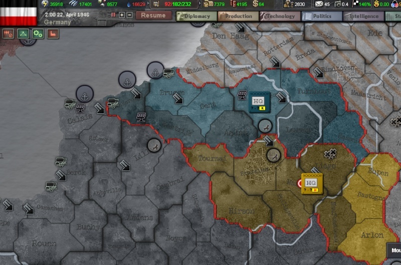
    Even though this is a double post, I still think it would be useful to post the base map and case-by-case explanation of European postwar border changes to this thread as well:
    http://strangemaps.files.wordpress.com/2007/10/uusieurooppa.png

    See the numbers of map for reference:
    1. Free City of Danzig, created as a result of the Versailles treaty, was regained by Germany in 19 September 1939 and incorporated into Reichsgau Danzig-Westpreussen. Danzig became an important industrial city dominated by shipbuilding, petrochemical and chemical industries.

    2. Memel Territory, occupied by Lithuania in 1923, was regained by diplomatic solution in 23 March 1939 (”Heim ins Reich“) after a popular revolt. It was incorporated into East Prussia. City of Memel was quickly turned into a fortified naval base. The reunion was welcomed by the majority of population. According to the treaty, the citizens of Memel Territory were allowed to choose citizenship: either German, or Lithuanian; only 303 choose Lithuanian.

    3. Reichsgau Wartheland was annexed to German Reich in 8 October 1939. Capital of the Reichsgau Wartheland is Posen (former Poznan)

    4. Former German imperial province of Elsaß-Lothringen (taken by France in 1919) was informally annexed by Germany in 15 June 1940. Alsace was incorporated into Gau Baden-Elsaß, with Straßburg as a capital (Karlsruhe until 1953). German parts of Lorraine were incorporated into Saarland (Gau Westmark), governed from Neustadt. German became the sole official language; use of French or local Alsatian was discouraged. The annexation, while ending the two decades of fierce anti-German discrimination, was never popular among the populace and NSDAP membership in Elsaß-Lothringen remained low. Elsaß was home to many student uprisings in the 1960s.

    5. The Grand Duchy of Luxembourg was occupied in 10 May 1940. It was officially annexed by Germany in August 1942 by incorporating it into district of Koblenz-Trier. New Reichsgau Moselland was governed from Koblenz. All luxembourgers received German citizenship. 13,000 young men were conscripted to the Wehrmacht, 2,848 were killed in the Eastern Front. In 1953, Letzebourg dialect received official recognition from Führer Rudolf Hess; however, German remained as the sole official language.

    6. Eupen-Malmedy, occupied by Belgium in 1919, was regained by Germany in 1940, with the clear consent of most of the inhabitants. Support for the German takeover eroded sharply after the Operation Barbarossa and the subsequent conscription of most of the male population in the Wehrmacht (out of 8,700 drafted new Germans, 3,200 perished in the East). In December 1944, Allied bomber raids first destroyed Malmedy, then Sankt Vith almost completely.

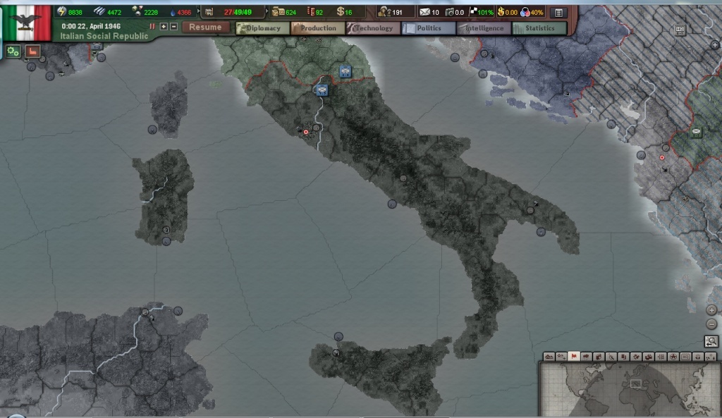
    7. Nice (Nizza) was occupied by fascist Italy in 15 June 1940. It was annexed in 12 November 1942 and retained by the Social Republic of Italy. About half of the inhabitants are French- or Occitan-speaking.

    8. Savoy region, occupied and absorbed by Napoleon III in 1860, was administered by fascist Italy in 1940-1941 and annexed in 12 November 1942. Although fiercely contested by premier Pierre Laval, Savoy remained in italian hands and became an autonomous region in the Italian Social Republic.

    9. South Slavic country of Slovenia, part of the former Kingdom of Yugoslavia, was partitioned in 3.5.1941 between fascist Italy, Germany and Hungary. Western Slovenia became Italian territory, Spodnja Štajerska (Untersteiermark) was annexed to the German Reich and completely Germanized, administered from Laibach (former Ljubljana).

    10. Dalmatia was annexed by Italy in 20.5.1941. Provincial capital was established at Zara (Zadar). Many Croats moved away from the Italian Governatorato di Dalmazia and took refuge in the Independent State of Croatia, which subsequently became the fighting ground for a guerilla war between the Axis and the Partisans. Remaining Croats opposed violently to marginalisation of the Croat language in Dalmatia. Legendary FC Hajduk of Spoleto (Split) refused to play in Italian league. In 1943-1945, there was an influx of Italian fascists fleeing from southern Italy, occupied by the Allied forces. The Dalmatian Question has strained the relations between Croatia and Italian Social Republic ever since.

    11. Hungary occupied and annexed in 19 April 1941 Hungarian parts of Slovenia and Croatia, called Muravidék (Prekomurje) and Muraköz (Medimurje).

    12. Baranja and Backa, inhabited by ethnic Hungarians, were regained by Hungary at the Treaty of Vienna (19 April 1941).

    13. Banat region was always officially part of the Serbian state, but in practice the Danube-German minority (volksdeutsche) lobbied and received concessions which made it fully autonomous region during the war. 7. SS Gebirgs-division Prinz Eugen was recruited among the Danube Germans.

    14. Kosovo (Kosovë in Albanian) was united with fascist Albania in 12 July 1941, with seat of local government in Prishtinë.

    15. Epirus and Pindos (Printsipat di la Pind) is a small puppet state composed of ethnic Aromanians (Vlach), Greeks, Albanians and Slavic Macedonians. The area of Epirus and Pindos was claimed by Albania but given to Aromanian separatists by Mussolini government in 1941. The capital of the statelet was Metsovo (Aminciu in Aromanian), but the national assembly sat in Trikala. The first prince of Pindos, Aromanian activist and poet Alkhiviad Diamandi, left his chaotic princedom in 1942 and took refuge in Romania. Greek partisans took over most of the area. Italian occupation authorities tried then to rely on local Macedonian activists, who were waging their own guerilla war both against the Bulgarian army and the Greek partisans. The state collapsed after Italian capitulation in September 1943, and the area was taken over by the Germans. German army favoured the Albanian claims over Greeks, and Principality of Pindos was re-established in 1944 with M. Hatzi as the Minister-President. Deadly partisan warfare continued for many years. Minister of Defense, Albanian-born Vasil Rapotika, was shot dead by a Greek guerilla group just outside Larissa in 1945. Finally, in 1949 Epiros and Pindos was annexed by Albania as an autonomous principality.

    16. Macedonia, also called Old Serbia, had become Serbian territory in 1912 and during 1929-1941 it was part of the Kingdom of Yugoslavia. When Bulgarian army occupied it in 18 May 1941, most of the local population hailed the Bulgarians as liberators. Local Macedonian revolutionary movement VMRO (Vnatrešna Makedonska Revolucionerna Organizaciya) split into several splinter groups, some of which opposed the occupation, others supporting it. Armed anti-Bulgarian separatists tried to establish an independent Macedonian Voivodeship in 1942, but they were defeated by the combined German and Bulgarian armies. VMRO continued its terror campaign along with Tito’s Partisan movement until 1949, when Bulgaria regained most of Macedonia. Violence escalated again in the 1960s, with both Albania and Greece covertly assisting Macedonian separatists against Bulgaria. Germany was forced to deploy two SS-divisions as peacekeepers, but even with the full German military might and equipment, peace is nowhere in sight.

    17. After Greek capitulation in 18 May 1941, Western Thrace, Thasos and Samothrace were all occupied by Bulgarian Army. Germany retained a narrow security zone in the Turkish border until 1949 when it was given back to Greece, infuriating the Bulgarians. Thracian question is still hotly debated in the European Parliament at Berlin.

    18. The Dodecanese Islands declared independence from Ottoman Turkey in 1912, but had been immediately occupied by Italy. Greece demanded the islands for herself, but the Greek defeat in the Greco-Turkish War and the foundation of modern Turkey made this solution impossible. With the Treaty of Lausanne the Dodecanese was then formally annexed by Italy, as the Possedimenti Italiani dell’Egeo. After the surrender of Italy in 1943 the Dodecanese were conquered by Germany in the Battle of Leros and remained in Axis hands. Hitler used the islands as a bargaining chip to get concessions from both collaborationist Greek government and the Italian Social Republic. Rhodes remains as an important military base for Axis forces.

    19. Distrikt Galizien. Historical region of East Galicia has formerly belonged to Austria-Hungary, Poland and Soviet Ukraine. Short but brutal repression under Soviet rule came to an end when Germany occupied East Galicia during Operation Barbarossa. In 30 June 1941 Yaroslav Stetsko declared Goverment of independent Ukraine in Lemberg (pol. Lvov, ukr. Lviv), but without German approval, and Galicia was subsequently incorporated into the GeneralGouvernment as Distrikt Galizien. As Germany viewed Galicia as already germanized and civilized (being former part of Austria), occupation policies were quite lenient. Conflicts in Galicia and Volhynia between Poles and Ukrainians also intensified, with skirmishes between Polish Home Army, Ukrainian Insurgent Army and Soviet Partisans. Despite these warring factions, many Galicians joined Germany in its fight against communism. It remains part of the GeneralGouvernment, with Lemberg as the eastern cultural capital of the Greater German Reich.

    20. Bialystok Voivodeship was annexed to East Prussia in 22 June 1941. National Socialist government pursued a ruthless program of forced germanization, which led to a major insurrection on 15 August 1943, organised by AOB (Polish Anti-fascist Military Organisation).

    21. Sudauen. Former Polish county of Suwałki had been captured by the Red Army in 1939, but was transferred to Germany according to the First Ribbentrop-Molotov Agreement. In 12 October 1939 it was renamed Sudauen and incorporated into East Prussia. In spite of severe German countermeasures, Polish underground resistance continued a limited guerilla war until 1956, when the last organised armed groups were eliminated.

    22. Transnistria. Separate peace negotiated in Stockholm between the Axis powers and the Soviet Union guaranteed the regions of North Bukovina, Bessarabia and Transnistria to Romania. Hitler persuaded Ion Antonescu to accept Transnistria as a substitute for Northern Transylvania, which was returned to Hungarian control in 1940. From 1943, Transnistria has been a part of the Greater Romania, with regional capital in Odessa. Transnistria is now among the poorest regions in the New Europe, with standard of living comparable to developing countries.

    23. Nevel. Southern part of the former Pskov oblast was annexed by the Reichskommissariat Ostland in 1943. The oblast had suffered terrible damage in the bloody battles of 1941-1942, in which the city of Velikiye Luki was utterly destroyed and never rebuilt. As most of the Russian-speaking inhabitants had fled, the area was deemed suitable for colonisation. In 1951 Nevel became the easternmost gau in Latvia and it received a substantial Latvian immigration. It still has a significant Russian minority (314 000 people).

    24. Pleskau and West Ingria. Northern parts of the Pskov oblast and West Ingria were initially selected for the German colonisation effort in the secret Generalplan Ost (GP), prepared by the Race and Resettlement Main Office (RuSHA) of Heinrich Himmler. They were first incorporated into Reichskommissariat Ostland in 1943 and became part of autonomous Reichsbezirk Estonia in 1951. Three German cities were constructed in 1944-1951: Jamburg, Luga and Pleskau, with total German population of 89,000.

    25. Reichsbezirk Petersburg. Former Russian metropolis of Leningrad was devastated in the war. Famous palaces and churches were turned into rubble by German artillery and aerial bombing. Stalin had forbade any notion of surrender; the city was not captured until in 1943 by joint German-Finnish force and with heavy casualties. At first Hitler and Finnish prime minister Ryti supported for total annihilation of Leningrad, but finally it was agreed that Germany would annex the area and make it a major supply center for the Axis armies fighting in Russia. From the ruins of Leningrad RAD constructed a German Freiestadt Petersburg with 500,000 permanent inhabitants, thus closing Russia’s “Window to the West” permanently.

    26. Reichsbezirk Gotenland became the German colony in the Eastern Europe, a Lebensraum for two million inhabitants (67 % German, 24 % Tatar, 5 % Armenian and 4 % Greek). It consists of the Crimean peninsula, isthmus of Perekop and outlying territory south of Dnepr (Generalbezirk Taurida). During the war it was fiercely contested by both Red Army, and after the war by pro-Soviet partisans who held out in the mountains of Crimea until 1954. In post-war years, Gotenland thrived as a prime tourist destination, built with new attractions and sanatoriums for tourists, who came from all around the New Europe. Crimea’s infrastructure and manufacturing was developed, particularly around the sea ports at Kerch and Theoderichshafen and in the Gotenland’s landlocked capital, Gotenburg (former Simferopol). Crimean Tatars enjoy cultural autonomy.

    27. Chechnya-Ingushetia. Having suffered years of Soviet repression, Chechen leaders Israilov and Sheripov formed a rebel pro-Axis government in May 1942, in order to regain independence with German aid. After the Second Ribbentrop-Molotov Agreement, Chechen National Council continued to support the Axis cause. When the promised cultural autonomy was slow to materialize, the region once again experienced increased partisan activity and unrest.
    Black Guardian
    Black Guardian
    Admin


    Posts : 192
    Join date : 2009-06-13
    Location : Saxony

    Borders in Europe Empty Re: Borders in Europe

    Post  Black Guardian Tue Mar 23, 2010 1:55 pm

    I´m doing Flanders & Wallonia now. Flanders is done, Wallonia will follow.

    Borders in Europe Flande10
    Karelian
    Karelian


    Posts : 230
    Join date : 2009-08-11

    Borders in Europe Empty Re: Borders in Europe

    Post  Karelian Tue Mar 23, 2010 2:15 pm

    Balkans are almost done, I´ll post screenshots after I come back from work. I´ll move on to Eastern Europe next. One thing that saved me a ton of time and trouble:
    potski's OOB Editor. It has a province finder that works for both names and province IDs:
    http://forum.paradoxplaza.com/forum/showthread.php?t=418702
    Add this to your "How to?"-FAQ and anyone willing to help will be do so with considerable ease.
    Karelian
    Karelian


    Posts : 230
    Join date : 2009-08-11

    Borders in Europe Empty Re: Borders in Europe

    Post  Karelian Tue Mar 23, 2010 11:58 pm

    Edit: The New Order in the Balkans is ready:
    Borders in Europe Balkan

    The next step will be new Romanian eastern border, followed by the Caucasus region
    Karelian
    Karelian


    Posts : 230
    Join date : 2009-08-11

    Borders in Europe Empty Re: Borders in Europe

    Post  Karelian Wed Mar 24, 2010 5:01 pm

    Postwar eastern border of Romania:
    Borders in Europe Uusromania
    Karelian
    Karelian


    Posts : 230
    Join date : 2009-08-11

    Borders in Europe Empty Re: Borders in Europe

    Post  Karelian Thu Mar 25, 2010 7:58 pm

    Postwar Finland:
    Borders in Europe Raja2.th

    and German colony region of Ingermanland:
    Borders in Europe Raja1.th
    Black Guardian
    Black Guardian
    Admin


    Posts : 192
    Join date : 2009-06-13
    Location : Saxony

    Borders in Europe Empty Re: Borders in Europe

    Post  Black Guardian Sun Mar 28, 2010 11:40 am

    Soo, I am back now (there was no Internet in the hotel, you had to pay and even then it wouldn´t work...) and I see that there is some nice progress!
    Good work there.

    For the lack of Internet I only finished Wallonia, better than nothing, but by far not as much as you did.
    By the way, there seems to be some provinces that look a bit odd (occupied by Germany probably) in the Croatia-Hungary-Romania Triangle and north of Bulgaria (where the HQ is located in your screenshot) - just in case you didn´t notice and corrected it yet Smile

    What is now left to do on the Border-"front"?
    Karelian
    Karelian


    Posts : 230
    Join date : 2009-08-11

    Borders in Europe Empty Re: Borders in Europe

    Post  Karelian Sun Mar 28, 2010 3:01 pm

    Those occupied provinces in picture are corrected.
    To do-list at Europe at the moment since the Baltic states are done (I don´t have a screenshot yet):
    -Belarus
    -Ukraine
    -Caucasus
    -German-occupied Russia that later on becomes the Moscow Federation
    -Northern Iran
    -Chinese Civil War
    -Madagascar occupied by Britain
    -Indochina (I´ll have to add map here)
    -Middle East (Free French-controlled Syria and Lebanon)


    Basically all the small bits in Europe are done now and what´s left are the major border changes in Eurasian Russia and colonial borders in Africa and Asia. I´ll see to them in the beginning of next week although they´ll undoubtedly take some time to finish.

    Edit: Borders in Middle-East and Africa are things I planned to do later, so if someone else has spare time feel free to edit them Cool
    Black Guardian
    Black Guardian
    Admin


    Posts : 192
    Join date : 2009-06-13
    Location : Saxony

    Borders in Europe Empty Re: Borders in Europe

    Post  Black Guardian Sun Mar 28, 2010 4:36 pm

    Looking at the list this just seems as if we are finished quite soon with the borders, though one should not underestimate the number of provinces in Russia...

    Basically, as I am back now and still have almost 2 weeks of free time, just provide me some maps/screenshots with things you don´t like to do (Middle East is my favourite in your list right now, could imagine to do Indochina and Chinese Civil War setup as well as changes in the Caucasus, but would dislike to do the things in Northern Russia) - and I will look if I find some time when I feel bored Smile

    And while we are talking about Africa - which changes did happen there? Decolonization is supposed to be a ingame-progress rather than a pre-set condition, isn´t it? Even India will belong to Britain in the beginning (we probably have to make it independant for Economy-Mod purposes though, same for Indonesia, as Zerli pointed out) - so, what are the changes there? Basically French Territory, right?
    Karelian
    Karelian


    Posts : 230
    Join date : 2009-08-11

    Borders in Europe Empty Re: Borders in Europe

    Post  Karelian Mon Mar 29, 2010 10:34 pm

    While editing the map is easy and fun enough, I really appreciate your help. I´ll post the screenshots for to-do map editing later tonight.
    Karelian
    Karelian


    Posts : 230
    Join date : 2009-08-11

    Borders in Europe Empty Re: Borders in Europe

    Post  Karelian Mon Mar 29, 2010 11:39 pm

    First of all, here are the postwar Balkans just to show how they turned out Cool
    Borders in Europe Balkank.th

    And here is the initial to-do for Indochina:

    While most of the region is initially in British occupation (all except northern part of modern-day Vietnam that is occupied by Nationalist China), here are the final borders:
    Borders in Europe Indokiina.th

    And here is the demarcation line - Vietnam north from here is occupied by Nat.China at the beginning of the scenario.
    Borders in Europe Demarkaatio.th

    In Africa things are initially almost like they are currently - just turn Madagasgar British-occupied. In Middle-East things are also almost correct - just replace independent Lebanon by Free French control that already covers Syria.
    Black Guardian
    Black Guardian
    Admin


    Posts : 192
    Join date : 2009-06-13
    Location : Saxony

    Borders in Europe Empty Re: Borders in Europe

    Post  Black Guardian Tue Mar 30, 2010 1:04 pm

    Soo, I just did Indochina - I hope you don´t wanted "occupied" as striped territory, I just gave ownership & control to britain & china, no fancy specialties - especially as I had no idea who could be the owner if the control is given so someone else. Japan? Vietnam? France? So I just chose the most simple path.

    Borders in Europe Indoch10

    And, just to give you a complete view, Flanders & Wallonia.

    Borders in Europe Flande11

    Next up: Southern China, merging the Warlords Territory into Nat. China
    Karelian
    Karelian


    Posts : 230
    Join date : 2009-08-11

    Borders in Europe Empty Re: Borders in Europe

    Post  Karelian Tue Mar 30, 2010 2:57 pm

    Good job! I´ll start the province overhaul in former USSR.

    Chinese postwar theatre will definitively need extensive attention, but initially you should the simple border layout of this map: - oh, and make whole Korean Peninsula US-occupied.
    http://www.emersonkent.com/images/china_1947.jpg

    After this basic border is done on we´ll tune it a little by adding these guerrilla base areas to the general picture as occupied ComChi territories in NatChi control:
    http://www.emersonkent.com/images/china_1945.jpg
    Black Guardian
    Black Guardian
    Admin


    Posts : 192
    Join date : 2009-06-13
    Location : Saxony

    Borders in Europe Empty Re: Borders in Europe

    Post  Black Guardian Tue Mar 30, 2010 3:19 pm

    Thank you for the maps, I just wanted to ask for some, as I could not find any sufficient ones through google, when I saw that you posted them Smile

    Right now, I am just doing very rough merging of the Warlord-territory to the specific factions (Guanxi, Xibei San Ma & Siankiang to Nat. China and probably Shanxi to Com. China). I hope that´s okay for the first base for fine-tuning.
    The main questions that are arising at the moment are:

    -What to do with Manchukou?
    Soviet Occupation took until Autumn of 1945, after that the fighting was already going on, but it is not clearly depicted that the Communists had a strong presence in Manchuria after Soviet retreat

    -Taiwan still under US-occupation or already in Nat. Chinas realm?
    Karelian
    Karelian


    Posts : 230
    Join date : 2009-08-11

    Borders in Europe Empty Re: Borders in Europe

    Post  Karelian Tue Mar 30, 2010 6:11 pm

    Black Guardian wrote:The main questions that are arising at the moment are:

    -What to do with Manchukou?
    Soviet Occupation took until Autumn of 1945, after that the fighting was already going on, but it is not clearly depicted that the Communists had a strong presence in Manchuria after Soviet retreat

    -Taiwan still under US-occupation or already in Nat. Chinas realm?

    Well, the Soviets are neverthless going to dismantle the Manchurian industry and transport it to USSR, and most likely they will allow Chinese Communists to establish their presence to the borders of Manchuria - KMT will nevertheless send in it´s best troops as in OTL and take control of regions around Manchurian Railway. I´ll provide you an additional screenshot about initial borders in Manchuria later on once I´ve studied the matter a little further.

    -Taiwan should be part of Nat.China, since US Navy brought in KMT troops on October 25, 1945 to take control from surrendering Japanese garrison.
    Black Guardian
    Black Guardian
    Admin


    Posts : 192
    Join date : 2009-06-13
    Location : Saxony

    Borders in Europe Empty Re: Borders in Europe

    Post  Black Guardian Tue Mar 30, 2010 8:01 pm

    Okay, Korea is done now. I added cores to all of Korea for PRK and KOR, to make it possible to release one united Korea. Furthermore I removed Japanese Cores, as they will probably be gone with the peace-treaties with the US.
    Same procedure will follow for Taiwan.

    And then I´ll put Manchuria under complete Communist Chinas control for now, until I get a good map that properly depicts the fighting there.

    By the way, I read that the Nationalists had serious troubles with Corruption during the civil war, which was probably one reason for their defeat - possibly another good use for the modifiers I want to implement later with the economy-system? With some nasty effects on your fighting capability? Wink
    But right now thats only brainstorming... but this idea from the economy-section might fit well together with other parts, that´s what I wanted to point out.
    Black Guardian
    Black Guardian
    Admin


    Posts : 192
    Join date : 2009-06-13
    Location : Saxony

    Borders in Europe Empty Re: Borders in Europe

    Post  Black Guardian Fri Apr 02, 2010 3:19 pm

    So, work on China has been completed in Stage 1.
    The blunt reductionist setup right now looks like that:

    Borders in Europe China_10


    For further editing in this field I need some good maps where the actual military & political situation in all this chaos is more clearly defined. Maybe I´ll leave this fine-crafting to you, if you prefer doing it instead of drawing me sketches. Your choice Wink

    But I have another nice screenshot - as you provided a map with major railroad-lines and my research told me that fighting in the Chinese Civil war took place among major railroad lines, I just started modeling them better ingame:

    Borders in Europe China_11

    Now China & Manchuko have the railroads that were visible on the map ingame as well - at least roughly Wink
    I´ll do the same with India if I get similar maps about Indian railroads, as I deem the Paradox-approach of giving all of India 80% Infra inappropriate.
    With such simplification its no surprise the supply-model doesn´t work too well Wink
    Karelian
    Karelian


    Posts : 230
    Join date : 2009-08-11

    Borders in Europe Empty Re: Borders in Europe

    Post  Karelian Mon Apr 05, 2010 9:35 am

    Good progress once again. Personal life has kept me away from editing for this weekend, but during this week I should be able to finish the border changes in European Russia and Caucasus. Cool
    Edit: With railroads modelled in China I think we´d better overhaul the overall infra elsewhere as well once we´re done with the borders?
    Black Guardian
    Black Guardian
    Admin


    Posts : 192
    Join date : 2009-06-13
    Location : Saxony

    Borders in Europe Empty Re: Borders in Europe

    Post  Black Guardian Mon Apr 05, 2010 12:05 pm

    Karelian wrote:Good progress once again. Personal life has kept me away from editing for this weekend, but during this week I should be able to finish the border changes in European Russia and Caucasus. Cool
    Edit: With railroads modelled in China I think we´d better overhaul the overall infra elsewhere as well once we´re done with the borders?

    Ah, there he finally is again.
    Out of boredom I did some work on the economy-section and implemented law-effects and tried to build the first event, but the game is so screwed with errors even without our mod (at least according to the Validator), that we need a proper debug first...

    Otherwise properly working things do not work (I set a flag in the history/country-file and tried to make it trigger an event, but it doesn´t work Shocked localisation is completely screwed as well, "decay" command unfortunately does not work for laws and triggered modifiers won´t work either at the moment...) something must be horribly wrong there and we have to correct that. But first I propose that we finish the map-stuff and create a standardized version out of this, to which we can then add other things like our technology- & economy-stuff.
    Karelian
    Karelian


    Posts : 230
    Join date : 2009-08-11

    Borders in Europe Empty Re: Borders in Europe

    Post  Karelian Mon Apr 05, 2010 9:36 pm

    Black Guardian wrote:
    Ah, there he finally is again.

    No worries, I´m not going anywhere Cool

    Black Guardian wrote:Out of boredom I did some work on the economy-section and implemented law-effects and tried to build the first event, but the game is so screwed with errors even without our mod (at least according to the Validator), that we need a proper debug first...

    Otherwise properly working things do not work (I set a flag in the history/country-file and tried to make it trigger an event, but it doesn´t work Shocked localisation is completely screwed as well, "decay" command unfortunately does not work for laws and triggered modifiers won´t work either at the moment...) something must be horribly wrong there and we have to correct that. But first I propose that we finish the map-stuff and create a standardized version out of this, to which we can then add other things like our technology- & economy-stuff.

    Sounds reasonable, once we have the map done and debugged version out I can start truly testing the land doctrine system as well. With so many changes we are bound to meet such errors, and I´m confident that we´ll sort them out eventually.
    Black Guardian
    Black Guardian
    Admin


    Posts : 192
    Join date : 2009-06-13
    Location : Saxony

    Borders in Europe Empty Re: Borders in Europe

    Post  Black Guardian Mon Apr 05, 2010 10:54 pm

    Karelian wrote:

    Sounds reasonable, once we have the map done and debugged version out I can start truly testing the land doctrine system as well. With so many changes we are bound to meet such errors, and I´m confident that we´ll sort them out eventually.

    The problem is not our work, but rather the fact that we got a very bugged foundation to work on. I don´t know wether it´s any better in your case, but you can just try to run the validator on the basis we use (HoI 3 1.3 + Magrathea) and you´ll encounter MANY errors that just have to do with Magrathea or vanilla HoI. Unfortunately, WE are the ones to carve these out, otherwise it won´t work for us... except we want to wait again until KrazyKarl delivers a completely error-free version which takes time & might never happen. Thats the problem.
    Karelian
    Karelian


    Posts : 230
    Join date : 2009-08-11

    Borders in Europe Empty Re: Borders in Europe

    Post  Karelian Tue Apr 06, 2010 12:11 am

    Black Guardian wrote:
    Karelian wrote:

    Sounds reasonable, once we have the map done and debugged version out I can start truly testing the land doctrine system as well. With so many changes we are bound to meet such errors, and I´m confident that we´ll sort them out eventually.

    The problem is not our work, but rather the fact that we got a very bugged foundation to work on. I don´t know wether it´s any better in your case, but you can just try to run the validator on the basis we use (HoI 3 1.3 + Magrathea) and you´ll encounter MANY errors that just have to do with Magrathea or vanilla HoI. Unfortunately, WE are the ones to carve these out, otherwise it won´t work for us... except we want to wait again until KrazyKarl delivers a completely error-free version which takes time & might never happen. Thats the problem.

    Tsk, didin´t think about it that way. Well, once we get the borders done it´s time to focus on this issue.
    Luckily most of the errors I see are seemingly caused by the fact that the code in text files is not properly arranged:

    Code:
    owner = SAU

    controller = SAUadd_core = SAU
    add_core = ARA
    add_core = OTTinfra = 4

    And this is luckily something something that will be relatively manual and simple to fix. As for bugs in vanilla code, that is naturally a different story...
    Black Guardian
    Black Guardian
    Admin


    Posts : 192
    Join date : 2009-06-13
    Location : Saxony

    Borders in Europe Empty Re: Borders in Europe

    Post  Black Guardian Tue Apr 06, 2010 12:31 am

    That´s not that much of a problem to correct... but really time-consuming for more than 10.000 provinces. And a necessity to make it completely bug-free.

    Furthermore, it doesn´t seem to ALWAYS cause errors, because sometimes it´s only a display-issue with the windows-text-editor. If I open such files in Notepad it is displayed correctly.
    But in some instances it seems to be indeed wrong, seems like we have to rely on the validator here.

    Other serious fun is something like:
    -duplicate province files (yes, there are some - at least for me...) - sometimes the files are even completely empty
    -alot of (senceless) constructions with remove_core (which seems to work only for certain dates or the validator is wrong here) in the setup (soviet provinces)
    -problems in the CSV-data (though I don´t know what to correct here and how much of this is vanilla-related)
    -errors in the vanilla-OOB

    All in all, very time-consuming, but fortunately (thanks to the validator) we at least KNOW what to correct. Imagine we didn´t...
    Karelian
    Karelian


    Posts : 230
    Join date : 2009-08-11

    Borders in Europe Empty Re: Borders in Europe

    Post  Karelian Tue Apr 06, 2010 2:14 pm

    I´ll test the tools displayed in this thread tonight to see whether we´ll can ease our upcoming task:
    http://forum.paradoxplaza.com/forum/showthread.php?t=469638
    Karelian
    Karelian


    Posts : 230
    Join date : 2009-08-11

    Borders in Europe Empty Re: Borders in Europe

    Post  Karelian Thu Apr 08, 2010 8:26 pm

    Just finished Crimea, the next task is to finish Caucasus and edit single-province outlines for remaining countries, thus making it easier for those willing to help to "fill in" the remaining mass of provinces in European Russia.
    Karelian
    Karelian


    Posts : 230
    Join date : 2009-08-11

    Borders in Europe Empty Re: Borders in Europe

    Post  Karelian Mon Apr 12, 2010 6:55 pm

    The new eastern border of New Europe:
    Borders in Europe Itraja.th

    And the border in Caucasus.
    Borders in Europe Kaukasus.th

    I´ll add the outline borders for Belarus and Ukraine and after that all that is left is the manual adding of all remaining provinces. In other news, Magrathea 1.2 is out:
    http://forum.paradoxplaza.com/forum/showthread.php?t=429060
    Karelian
    Karelian


    Posts : 230
    Join date : 2009-08-11

    Borders in Europe Empty Re: Borders in Europe

    Post  Karelian Sat Apr 17, 2010 3:08 pm

    We´re making steady progress:

    Generalgouvernment and Distrikt Galizien.
    Borders in Europe Kenraalikuvernementti.th

    Ukraine.
    Borders in Europe Ukraina.th
    Black Guardian
    Black Guardian
    Admin


    Posts : 192
    Join date : 2009-06-13
    Location : Saxony

    Borders in Europe Empty Re: Borders in Europe

    Post  Black Guardian Mon Apr 19, 2010 10:23 pm

    Good.

    I have nothing new to report, except for installing the new Magrathea-Version, as the semester has begun and I didn´t feel like doing any additional work here until now - somehow I am still demotivated by the amount of debugging ahead Sad
    Karelian
    Karelian


    Posts : 230
    Join date : 2009-08-11

    Borders in Europe Empty Re: Borders in Europe

    Post  Karelian Tue Apr 20, 2010 12:51 am

    I´ve met all too many duplicated provinces as I´ve proceeded and had I know the issues this map mopd had while I first noticed the obvious benefits of Magrathea map build...Well, I would have certainly considered twice before suggesting it. Oh well, no use to cry over spilled milk. Maybe we should just stick on testing the other functions like the economy mod and land doctrines in install with vanilla map while debugging the Magrathea-based starting scenario?


    Last edited by Karelian on Tue Apr 20, 2010 2:53 pm; edited 1 time in total
    Black Guardian
    Black Guardian
    Admin


    Posts : 192
    Join date : 2009-06-13
    Location : Saxony

    Borders in Europe Empty Re: Borders in Europe

    Post  Black Guardian Tue Apr 20, 2010 11:27 am

    Karelian wrote:I´ve met all too many duplicated provinces as I´ve proceeded and had I know the issues this map mopd had while I first noticed the obvious benefits of Magrathea map build...Well, I would have certainyl considered twice before suggesting it. Oh well, no use to cry over spilled milk. Maybe we should just stick on testing the other functions like the economy mod and land doctrines in install with vanilla map while debugging the Magrathea-based starting scenario?

    Certainly, if we can live with the fact that we have no 1946-scenario setup then. Better than no progress in these other fields, if you ask me. Maybe we should tell KrazyKarl about these issues, all in all, it is his mod and in his interest to not only provide partly-playable, but a fully-working edition, at least if he has the possibilities to check this easily (Validator)
    Karelian
    Karelian


    Posts : 230
    Join date : 2009-08-11

    Borders in Europe Empty Re: Borders in Europe

    Post  Karelian Tue Apr 20, 2010 2:54 pm

    Black Guardian wrote:
    Karelian wrote:I´ve met all too many duplicated provinces as I´ve proceeded and had I know the issues this map mopd had while I first noticed the obvious benefits of Magrathea map build...Well, I would have certainyl considered twice before suggesting it. Oh well, no use to cry over spilled milk. Maybe we should just stick on testing the other functions like the economy mod and land doctrines in install with vanilla map while debugging the Magrathea-based starting scenario?

    Certainly, if we can live with the fact that we have no 1946-scenario setup then. Better than no progress in these other fields, if you ask me. Maybe we should tell KrazyKarl about these issues, all in all, it is his mod and in his interest to not only provide partly-playable, but a fully-working edition, at least if he has the possibilities to check this easily (Validator)

    Once I´ve edited my way through the sea of provinces that is European Russia I´ll certainly compile a fix list and send it over. But once provinces are done, I´m going back to tech editing, finishing the revised techs for theories and then further testing and balancing the new land doctrines.

    Sponsored content


    Borders in Europe Empty Re: Borders in Europe

    Post  Sponsored content


      Current date/time is Mon Apr 29, 2024 1:39 pm